Alpine Huts
The Alaska Alpine Club maintains three huts in the Delta Range. They are available on a first come first serve basis, and the doors are unlocked. There is no trash service nor maid service, so please leave the huts in good shape. Report hut problems to the Club. Please consider becoming an AAC member or contributing in another way to support the sustainability of these resources. Commercial groups or parties of 8 or more MUST check in with the club for availability before utilizing by emailing us at alaska.alpine.club@gmail.com.
Thayer Hut
4800 Feet
N 63° 27.156’ W 145° 32.181’
7.8 Miles (winter/summer)
2417 Feet Elevation Gain
4 to 8+ Hours

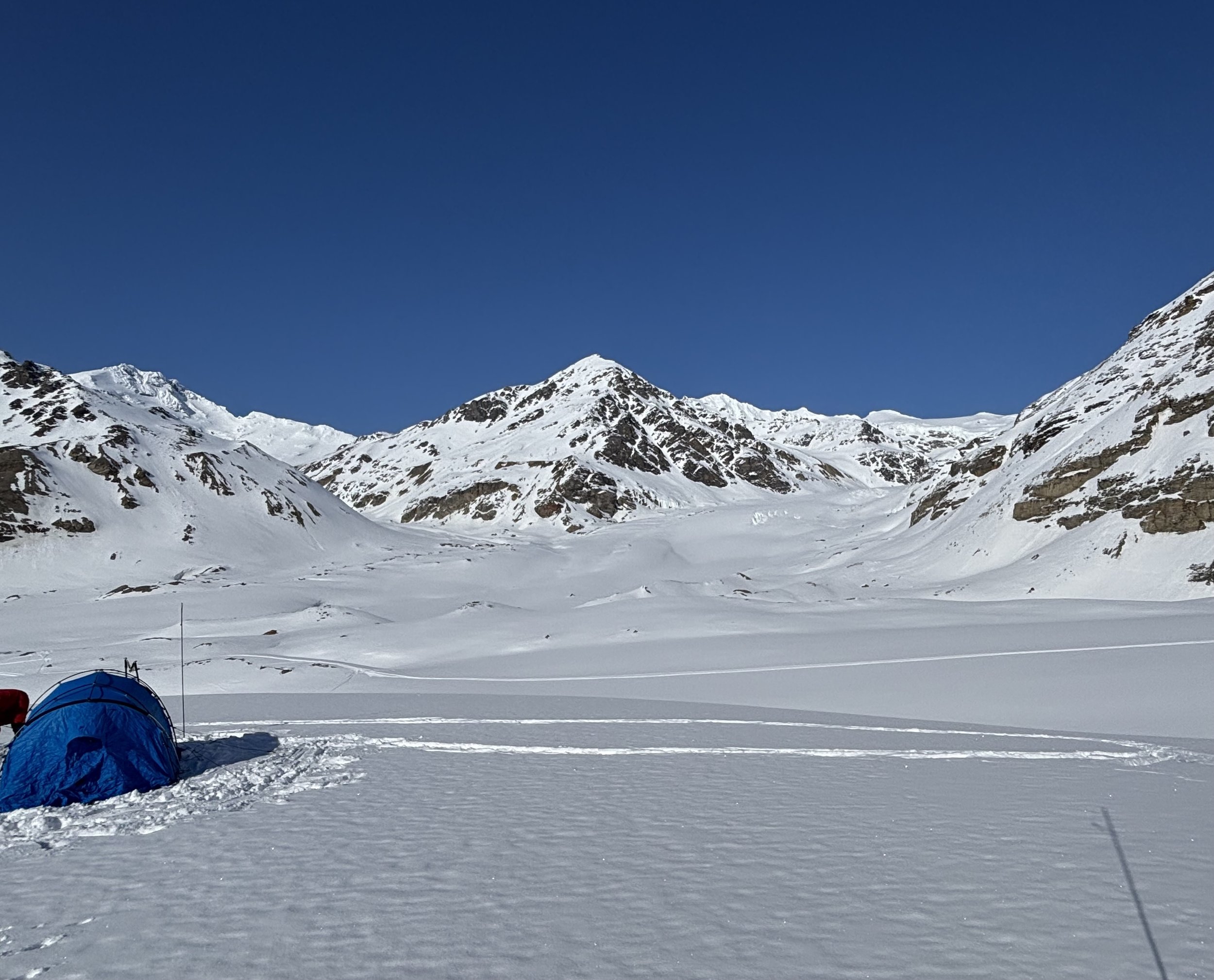
While returning from the first ascent of Black Cap in the spring of 1961, AAC member Bucky Wilson and others noticed the fantastic hut site, a green alpine meadow spared by two branches of the Castner Glacier. Later in the summer club members packed in the first 2 X 4s to begin construction. During the next 4 years over 100 loads of building materials were hauled on climber's backs and the hut was ready for use. There have been a few repair trips to replace and repair the outside sheeting and install a new door and floor but for the most part the hut has weathered well. The hut is 12' by 10' and sleeps 5. There are rumors of up to 10 people stuffed in for a night. The hut is well equipped with stove, lantern, pots, bowls, etc. Forty years of use has accumulated lots of stuff including a big library.
The hut tends to feel cramped due to the steep A frame design. Another problem was that the hut tended to get buried by snow making it hard to get inside. Great minds worked to solve these problems in the next 2 huts. But the third problem, global warming, is harder to solve. When the hut was built the Castner Glacier filled the valley making it easy to get from the glacier to the hut meadow. But through the years the glacier has dropped dramatically making the climb up to the hut an arduous and potentially dangerous climb.
During the winter there is snow to melt for water and in the spring there is a little creek running past the hut. But by July or August, Mary's rock is free of snow and the creek dries up. There is a reliable pond west of the hut. Head towards Item Peak. From the edge of the meadow you can see the pond down below.
To get to the Thayer Hut use the Castner Glacier access (page 10) and stay on the right hand moraine until you see an ice tongue on your left. Traverse down to the ice tongue. Avoiding likely moulin areas, go up the ice tongue until you reach the intersection of the 3 branches of the Castner Glacier. From here there are four options, one of which will be the best route for the current glacier conditions. A route may also be selected based on where the party plans to go from the hut. For example if Black Cap is the objective the White Princess Branch route might be selected.
Via White Princess Branch This route was the best route for many years but the crack free path seems to be getting narrower and narrower. The route gains the most altitude on the glacier which minimizes the final steep slope. Winter parties should be roped up. Start up the White Princess branch. It is critical where you go up the steeper section of the glacier because once you crest the hill you will either hit the crevasse free path or hit crevasses. If you split the glacier valley in half you want to start up right of center until you are over the steep section and have gone well past the hut and the crevassed zones on both sides. When past the worst of the broken up area cut back to the slope below the hut. Get off the glacier and climb the final slope.
Via Direct Assault The shortest steepest way with the least crevasse danger. Head directly to the nose between the Silvertip and White Princess Branches of the Castner Glacier. You will have to cross a moraine and deal with a messy zone as you approach the nose. Pick a route up the steep slope directly to the hut bench. With good snow conditions this can be simple cramponing up Styrofoam snow. With no snow it is scary climbing on steep mud. Parties have been avalanched off this slope.
Via Direct Assault + White Princess Branch (The authors current favorite route.) As above, head directly to the nose between the Silvertip and White Princess Branches. In the summer head for the apartment building sized red cliff. You will have to cross a moraine and deal with a messy zone as you approach the nose. Turn right along the edge of the White Princess Branch until you are past the cliff bands. Ascend grunge slope to the hut bench.
Via Silvertip Branch One can also go up the Silvertip Branch, skirting giant moulons, until you pass all the cliff bands. Pick your way through crevasses to get off the glacier and climb up to the bench diagonaling to the right.
Lower Canwell Hut
4200 Feet
N 63°20.107’ W 145° 31.492’
5.8 Miles (summer) / 7.3 Miles (winter)
1380 Feet Elevation Gain (summer) / 1700 Feet Elevation Gain (winter)
3 to 6+ Hours (summer) / 4 to 8+ Hours (winter)

By 1968 another hut site had been selected 7 miles up the Canwell Glacier. The frame was assembled on campus then taken apart and hauled up the glacier on people's backs. To give more room the 12 foot by 12 foot A frame design was modified by making the walls more vertical and having a 4 foot wide flat roof. And, to solve the deep snow access problem (and provide ventilation) a 2 foot by 2 foot hatch was built into the roof. The flat roof and hatch caused water leakage problems and eventually the hatch was eliminated. The wind exposed location prevented deep snow from accumulating so the hatch was unnecessary.
But, the biggest problem with the Lower Canwell Hut quickly became parky squirrels. There have been at least 4 major efforts to save the hut from the varmints. Wire mesh has been buried around the perimeter and various measures taken to exclude, repel, and even kill the critters. They chew up anything not made of metal. At one point we thought it was the plywood glue they were after so pine boards were hauled in for the floor and cedar siding for the walls. They chewed those up with abandon. The walls were re-insulated with foam boards - they devoured it. The 2001 - 2003 efforts involved more attempts to exclude them by installing a steel door, burying more wire mesh around the perimeter and tightly stacking rocks. The entire floor was covered with aluminum sheets and then plywood installed over the aluminum. And the lower walls on the inside were covered with aluminum. The hut is now varmint free and in good shape.
Since the hut has been abandoned at times the furnishings are sparten but there is a log book, Coleman stove, Coleman lantern, snow pail, a few pots, etc.
And then there are the bigger critters - Grizz! Claw marks are visible on the exterior sheeting. A bear broke in through the window in 2002 so the new window is trimmed with spikes.
The summer water sources are creeks E of the hut.
To get to the hut use the Red Rock Canyon access in the summer or the Lower Miller Creek access in the winter. In clear weather the shiny aluminum siding is visible from the glacier. In cloudy weather there are features that might help you find the hut. The glacier in the vicinity of the hut has two ice tongues, separated by a moraine. The central ice tongue extends further down glacier. The hut is about 1 mile up glacier from the terminus of the shorter, northern ice tongue. The hut is also located by the second major drainage in the ridge between the Fels and Canwell Glacier, but there are a couple of minor drainages. The hut is left of the first set of crevasses along the north margin of the glacier. A final landmark is a set of dramatic gullies in the lateral moraine just up glacier from the hut.
With care and local knowledge many people have gotten to the hut without a rope but there are hazards. There are water canyons and moulons in the ice tongues and crevasses just up glacier from the hut. The final slope to the hut is steep enough to avalanche.
Mackeith HUT
5500 Feet
N 63° 19.011’ W 145° 22.979’
10.7 Miles (summer) / 12.2 Miles (winter)
2600 Feet Elevation Gain (summer) / 3000 Feet Elevation Gain (winter)
5 to 8+ Hours (summer) / 7 to 12+ Hours (winter)

By the time this hut was built the AAC had resolved many of the design problems with the earlier huts. Using a gothic arch shape they achieved a spacious feel with no flat roof. The hut was built in an Eielson Air Force Base hanger, driven down the Richardson Highway, and slung in by military helicopter. The entire bottom of the hut was sheathed in aluminum to keep the critters out. A site was selected about 16 miles up the glacier but the pilots balked and put the hut down about 12 miles up glacier. It has remained there ever since. But only one corner was sitting on rock, the other corners were on snow. Club members went up and replaced the snow with rocks but one corner is over soft soils that persisted in going down despite several attempts to level the floor. In 2006 the hut was leveled with wood cribs and got a new door and windows. The hut is comfortable and has an interesting collection of things left by past parties. The log book makes for great reading.
Originally the hut was called "Upper Canwell Glacier Hut" but was renamed the MacKeith Hut after club president Peter MacKeith died while climbing Old Snowy in April 1980.
The Canwell Glacier has crevasses and moulons in the vicinity of the MacKeith Hut. Parties may need to be roped up to safely get to the hut. Good visibility or a GPS is needed to find the hut. As you head up glacier from the Lower Canwell Hut you will be traveling beside a prominent medial moraine. When this moraine turns from a high mound to scattered rocks you are about half way to the hut. Watch for moulons! The hut is on the north side of the glacier just beyond the first major glacier that enters the north side. (There is some ice in the smaller gully further down glacier) Imagine you are a helicopter pilot searching for some flat ground close to the glacier and free from avalanche danger. There are not many options except the hut location. The hut is only partly visible when coming up glacier as it sits behind a mound. There is a minivan sized rock which parties mistake for the hut (not a bad mistake as the hut is just over the knoll). The hut is clearly visible from up glacier appearing silver as it is clad in aluminum. A good landmark is the Gulkana Glacier pass as the hut is slightly down glacier from a point directly across from the pass. The bearing from the hut to the pass is 192 degrees. The hut elevation is some 500 feet below both the pass to the Gulkana Glacier and Yeti Pass.
Maps Sourced from CalTopo
Photo by AAC Member Helen Willard, Looking toward Thayer Hut